Untitled Document

Team 8+ are a group of independent researchers who
have been brought together by a mutual desire to find the real truth behind
the 9/11 attacks and other major world events.
The graphic below contains some introductory information about
plane swapping, please also read "Holes
in the Radar" and the other articles on this site for more information.
click
to enlarge
If you are interested in the subject matters on this site,
please sign up for an account. You can then participate in the forums, submit
news items, articles and links. Anyone being deliberately offensive or inflamatory
in the forums will be banned from the site!
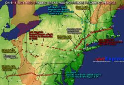
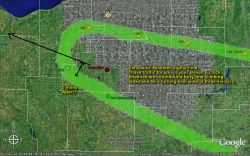
Animation showing military precision of flight paths
Note the MD80 is a McDonald Douglas plane mentioned in the air traffic control
transcript for Flight 11.
There is a network of military bases and airports on the East Coast laid out
in triangles with a side of roughly 100 miles
click
to enlarge
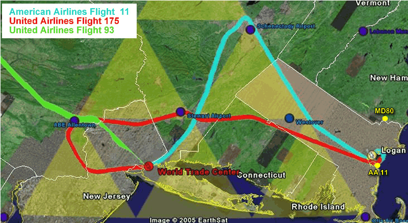
This becomes particularly interesting when we look at the flght paths for AA
Flight 11 and UAL Flights 175 and 93. The yellow triangles in this diagram are
equilateral with 100 miles sides. They act as a template to show that many of
the key points in the flight paths are 100 miles apart.
Note the locations of the air bases, especially Otis and Dover.
click
to enlarge
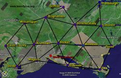
This "Chinese Checkerboard" pattern would be useful for timing rendezvous
points for planes that are otherwise unable to communicate.
The 9-11 planes took 13 to 14 minutes to travel each 100 mile section.
Lets look at the bizarre events that occurred:
Meeting point 1: Flight 11 is issued a "merging target
procedure" at 8.12. This is a warning to look out for another plane at
similar altitude who is on a converging path. Both planes will appear as one
spot on the radar. Just after these planes pass, Flight 11 stops responding
to radio.
Meeting point 2: Flight 175 takes off at almost exactly the
same time as Flight 11 is being hijacked. Due to the strange triangular path
that Flight 11 follows, both planes end up very close together near Stewart
Airport. The Controller turns Flight 175 to the right so he goes behind Flight
11 and avoids a collision.
Meeting point 3: Flight 93 (no transcript available) appears
to have been turned to the right at take-off to avoid flight 175. Both these
planes end up close together in the sky and for a brief period Flight 93 is
following Flight 175
Meeting point 4: Delta Flight 1989, another LA flight from
Boston that took off shortly after Flight 175 passes very close to Flight 93
just after it makes its U-turn over Cleveland airport. Delta 1989 was being
watched carefully for signs of a hijack and was (at this time) poiting towards
Chicago, home of the Sears Tower.
click
to enlarge
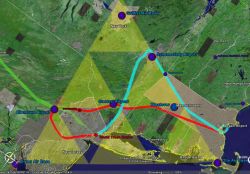
What makes these meeting points even less likely to be a coincidence is the
fact that meeting points one to three are in a straight line with exactly
100 miles between each point.
Here is a very simplified diagram of the flight paths with the lines straightened
a bit to emphasise the shape
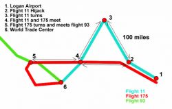
click
to enlarge
1. Take-off point Logan airport
2. Flight 11 stops responding
3. Flight 11 starts to turn South
4. Flight 11 and Flight 175 paths cross
5. Flight 175 starts to turn, Flight 93 very close in sky
6. WTC
The gaps between 2, 3, 4 and 5 are all 100 miles
Observe the timings
1. Flight 11 take-off a few seconds before 8:00
2. Flight 175 take-off 8:14 - Flight 11 hijack 8:14
3. Flight 11 turns south 8:27 (Flight Explorer)
4. Flight 11 and Flight 175 meet around 8:40
5. Flight 175 is turning over Allentown at around 8:53
In light of the fact that Flight 175 was supposed to depart from Boston at
8:00 am, perhaps the purpose of Flight 11's huge detour away from its target
was to allow Flight 175 to catch up with it. Or perhaps the delays of both Flight
175 and Flight 93 were arranged on purpose to allow these meetings. This would
seem less likely, but what if delays were caused by carefully planted passengers
causing issues on the ground?
Looking at what happened it was almost as if something was being passed
from plane to plane like a virus or parasite:
1. MD80 passes close to Flight 11
2. Flight 11 is hijacked
3. Hijacked Flight 11 passes close to Flight 175
4. Flight 175 is hijacked
5. Hijacked Flight 175 passes close to Flight 93
6. Flight 93 is hijacked (a bit later on)
7. Hijacked Flight 93 passes close to Delta 1989
8. Was Delta 1989 supposed to hit the Seers Tower?
And then there are the simultaneous events:
1. 8:13 Flight 11 hijacked/ Flight 175 takeoff
2. 8:42 Flight 175 hiajcked/ Flight 93 takeoff
3. 8:46 Flight 175 switches transponder code/ Flight 11 crashes
And there's the strange identical pattern taken by Flight 11 and Flight 175
- see the last frame of the animation above
The absurdity of the flight paths in general can be seen by looking
at the distance from the various airports to the various targets and comparing
them to the flight paths taken:
1. The distance from Dulles airport to the Pentagon 22 miles.
But the distance flight 77 took from Dulles to get to the Pentagon was 627 miles.
That’s an extra 600 miles to get intercepted, shot down or for suicide
hijackers to reconsider their actions.
2. Assuming Flight 93 was also targeting the Pentagon (as speculated
by the media). The distance from Newark to the Pentagon is 200 miles. The distance
flight 93 would have taken to reach the Pentagon is 750 miles. That’s
550 unnecessary miles.
3. The distance from Logan to the WTC is 193 miles. Flight
11’s route to the WTC was 328 miles (135 extra). Flight 175 took 368 miles
(175 extra).
4. The distance from Newark airport to the WTC is 8 miles.
You could see the towers from the runway.
Summary and Conclusions
A close analysis of the flight paths and ATC transcripts shows bizarre "meetings"
between the 9-11 planes and some other planes.
The distances (almost exactly 100 miles between most major events) and timings
(13 -14 minutes between each event) involved show that these meetings were carefully
planned and co-ordinated
The fact that these meetings were between hijacked and non-hijacked planes would
indicate that they were not planned by any hijackers on board the planes.
The paths and key events in the paths seem to coincide and line up with a network
of air bases and airports laid out in triangles on the East Coast. These bases
and airports are separated (with the exception of where terrain prevents it)
by roughly 100 miles
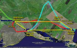
***UPDATE 6th Dec 2005***
Yet another very regular pattern. The significance of this is that both Flight
11 and Flight 93 flew to a point 65 miles away and at the same angle from departure.
At these respective points, Flight 11 became hijacked, Flight 93 was just behind
Flight 175, and flight 175 began to turn
click
to enlarge
Resources used:
Google Earth - for maps and distances
ATC transcripts published in the New York Times (see the forum http://www.team8plus.org/forum_viewforum.php?8
)
The 9-11 Commission report for the flight paths
Flight Explorer and Flytecomm flight paths for timings (see the downloads section)
Notes on how these maps were created
Using Google Earth you can create an overlay using an image file (e.g. jpg,
gif etc). If you use one of the flight path maps from either the commission
report or elsewhere - you can stretch and rotate the image until the state lines
line up with those on the map.
In the examples above I've lined up the state lines then edited the original
pic so that the background is transparent (this takes some knowledge of graphics
packages). You can adjust the "transparency" of the overlay in google
earth so that you can see the map underneath.
Don't take my word for it, try it yourself!
