Entered into the database on Sunday, December 04th, 2005 @ 18:18:22 MST
2005 has had more than its share of storms, and thus more than its
share of strange storms. The three Cat 5 monsters - Katrina, Rita and Wilma
- are joined by large eyed Ophelia, Spain striking Vince, and now Epsilon, which
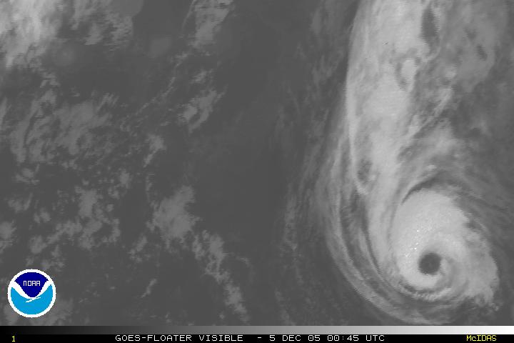
has been predicted to weaken and turn extra tropical over and over again, but... AFTER A SLIGHT WEAKENING OVERNIGHT...MORNING SATELLITE IMAGES THE UPPER LEVEL WINDS ARE EXPECTED TO BE If it befuddles Avila - one of the top tropical cyclone forecasters
in the world - it has got to be strange. Epsilon is a north and east hybrid storm - instead of starting out as an area
of thunderstorms and "convection" - hot air rising off the water - it
started the other way -as a strong swirl of winds that strayed far enough over
warmer water to pick up convection. Instead of being thunderstorms that go organized,
it is a barocyclonic low that went shopping. Over and over again NHC, the models
from computers, and basic statistical track records have said that Epsilon wouldn't
make hurricane, would lose the convection over colder water, would disspiate or
be absorbed, or picked up in the westerlies. Instead Epsilon got very organized,
acquired, and more ore less kept, an eye, has a good ring of convection, and has
strayed farther and farther south, thus buying more and more time. It is even possible, though very unlikely, that Epsilon will manage a "crazy
Ivan" - where it circles around south enough to regenerate strength. But
no more unlikely than what has already happened. Bet on it I wouldn't, but,
at this point, betting against this storm is a negative expecation proposition. Of course it will come to an end, but Epsilon, like Vince, has had a longer
run than any one expected for a December Atlantic storm. It is a warning that
warming Sea Surface Temperatures - SST in the lingo - will mean more late season
storms, and eventually perhaps landfalls of those storms. If the Gulf Stream
is indeed shutting down, then the possibility that cold lows will stray south
and pick up tropical characteristics grows higher, and sinc ethe air is colder,
it will take lower SST to create convection. It also holds implications for
the Southern Atlantic, because while the Southern Atlantic does not have what
is called "The Intertropical Convergence Zone" a belt of stormy weather
which is the nursery of normal tropical storms, strong barocyclonic lows often
wander in from the south, and could pick upt tropical characterisics in the
belt of warm water between Africa and South America. With a large number of
cities that have large shanty towns, this creates the long term potential for
a landfall in Brazil that could crete thousands oc casualties and hundres, even
thousands, of deaths.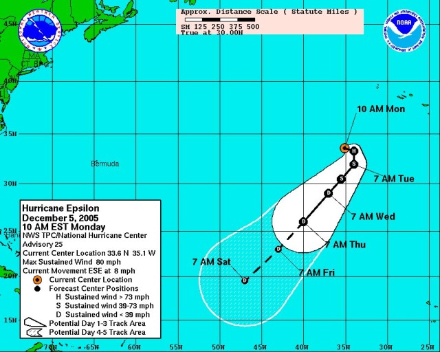
INDICATE THAT EPSILON HAS RESTRENGTHENED. THE EYE HAS BECOME MORE
SYMMETRIC AND THE RING OF CONVECTION IS STRONGER THAN YESTERDAY.
T-NUMBERS FROM TAFB AND SAB ARE 4.5 ON THE DVORAK SCALE AND ON THIS
BASIS...THE INITIAL INTENSITY IS INCREASED TO 75 KNOTS. THERE ARE
NO CLEAR REASONS...AND I AM NOT GOING TO MAKE ONE UP...TO EXPLAIN
THE RECENT STRENGTHENING OF EPSILON AND I AM JUST DESCRIBING THE
FACTS. HOWEVER...I STILL HAVE TO MAKE AN INTENSITY FORECAST AND THE
BEST BET AT THIS TIME IS TO PREDICT WEAKENING DUE TO COLD WATER
...HIGH SHEAR AND DRY AIR.
HIGHLY UNFAVORABLE AND EPSILON WILL LIKELY BECOME A REMNANT LOW. I
HEARD THAT BEFORE ABOUT EPSILON...HAVEN'T YOU?