Entered into the database on Sunday, October 23rd, 2005 @ 10:26:37 MST
-- UPDATED 4:50 AM October 19th With apologies for my unfortunate absence from this forum in recent days, for
weeks now we have been presenting (in previous "Captain's Blogs")
increasingly extraordinary images, archived radar data and expert testimony,
all supporting the (to some) equally extraordinary new reality: That, despite what experts tell us, the technlogy currently exists
to actually control the weather -- and specifically, nature's
most destructive type of storm: the hurricane itself. And that "someone" has been using this technology this summer "in
an undeclared, all-out 'weather war' against the United States" ... with
(after Katrina) disasterous results .... Tonight, we have discovered startling new evidence that we are right in this
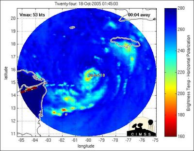
extraordinary model: New MIMIC microwave imagery -- again, from the University of Wisconsin -- of
the newly-formed Caribbean Tropical Storm, "Wilma." The latest image "loop" (above) demonstrates
an IDENTICAL "red tuning-fork interference signature" seen in
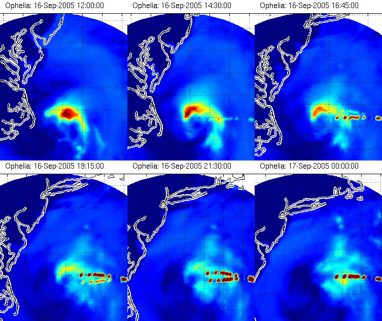
a previous Tropical Storm-turned-Hurricane: "Ophelia!" Here (below) is that archived Ophelia MIMIC loop ... complete with the
same remarkable "tuning fork" interference pattern showing up now
in recent "Wilma" images .... Note how Ophelia responds -- both in terms of the wind intensity and the literal
direction of the storm -- when this "tuning fork" pattern first appears. It is our contention, based on the physics of these images (described
at the official University of Wisconsin MIMIC site, here), that these bizarre
"tuning fork" patterns -- note, geometrically aimed at the
precise centers of these respective storms! -- are actually a "rainfall
side-effect" of an unseen energy technology being applied to these respective
storms ... in an effort to decrease both their wind velocities,
and to simultaneously alter the storms' tracks themselves.
[In a future "Captain's Blog," we will lay out the complete physics
(as we believe we currently understand it) behind what we are seeing in these
astonishing microwave images.] In the limited space we have here, suffice it to say that in this latest imagery
of Wilma we seem to be seeing the first visible effort to reduce the
strength of a potential hurricane; what we cannot see in this data,
is the application of additional technology (by an "opposing team"),
potentially attempting to enhance this same storm ... Wilma
... and then move it toward a specific "target" in this undeclared
"war." One important note: since we first called world-wide attention to these MIMIC
microwave radiometry images in an earlier "Captain's Blog," the University
of Wisconsin site has added a major "disclaimer" to all its posted
MIMIC imagery. The new clam is that we are "only seeing imaging anomalies"
-- created by the computer imaging process which creates these MIMIC imaging
products themselves. To which I have an obvious question: If this is truly the case -- if we are seeing in these striking geometric patterns
only "computer glitches" in the data -- why was this crucial "technical
disclaimer" ONLY added to the MIMIC site AFTER
we called attention here to the striking "geometric signatures" appearing
on certain hurricane images within the archive!? If this is truly just "a systemic computer problem," resulting from
the nature of the satellite data involved and the algorithms being used to handle
it, why was this disclaimer not posted on the site from the beginning ... for
all the official users of this data? Why not, indeed. I think you know our answer .... With that stated -- in the coming days, as additional MIMIC
imagery of Wilma becomes available, it will be crucial for everyone here to
watch for the appearance of additional "interference" signatures within
new data ... as well as their direct physical effects (as with
Ophelia!) on both Wilma's subsequent wind speeds ... and its direction of motion
towards a landfall! In this remarkable new data, we may be witnessing the first visible "confrontation"
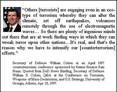
between two opposing forces (yet unknown ...) -- ushering in, as former Secretary
of Defense, William Cohen first warned us in 1997, a totally new era of "global
weather war" .... Stay tuned. Addendum AP is now reporting (about an hour ago) "Tropical
Storm Stalls in the Caribbean." This is in direct contradiction to
overnight (and still prevailing) forecasts, that Wilma will strengthen into
full hurricane status later this morning -- possibly reaching a Catagory 3 or
4 -- as it then moves northwest ... before looping northeast ... toward a Florida
landfall by the weekend! Is this evidence of the "interference technology/signature pattern"
actually working ...? Keep watching. :) Addendum 2 In the early hours of this morning, October 19th, 2005 -- less than 18 hours
after going from a Tropical Storm to a full-fledged Catagory 1 -- "Wilma"
reached a hurricane strength of Catagory 5, the maximum extension of the
Saffir-Simpson Scale. Her central pressure was measured at 882 millibars -- the lowest recorded in
a hurricane since 1935! Her internal winds (relayed by a U.S. Air Force hurricane
hunter aircraft in the eyewall just hours ago) were in excess of 175
miles per hour! This hundreds of times increase in intensity (the energy of
a hurricane goes up as the square of its peak wind velocity!) -- for a storm
that was barely in existence less than a day before (!) -- remarkably, began
precisely coincident with the cessation of the anomalous "red tuning fork"
geometry recorded earlier: at about 01:45 GMT, October 18th, 2005. This dramatic change in the overall intensity of this developing storm, simultaneous
with the disappearance of this "anomalous geometry," strongly supports
the idea that these mysterious "geometric rainfall patterns" -- seen
in the MIMIC microwave imagery prior to this cut-off -- were, indeed, somehow
responsible for actively suppressing the overall intensity development
of Wilma ... in the hours just before their disappearance! Again, this inversely correlated storm behavior argues compellingly that what
is being seen on the MIMIC images from the University of Wisconsin is not the
product of "a faulty computer program" -- but is, in fact, the signature
of a partially successful technological effort to actively suppress this
storm ... which, in this instance, was prematurely terminated! If this model is correct, we may look forward to other attempts to dissipate
this now extremely dangerous, Catagory 5 Hurricane before it makes landfall
in the United States -- using this same "interference" technology,
and leaving the same "geometric signature" -- across the coming days
.... Stay tuned.